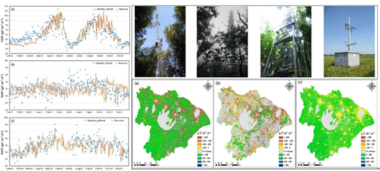
Land use changes play a major role in determining sources and sinks of carbon at regional and global scales. This study employs a modified Global biome model-biogeochemical cycle model to examine the changes in the spatiotemporal pattern of net ecosystem production (NEP) in the Taihu Lake Basin of China during 1985–2010 and the extent to which land use change impacted NEP. The model is calibrated with observed NEP at three flux sites for three dominant land use types in the basin including cropland, evergreen needleleaf forest, and mixed forest. Two simulations are conducted to distinguish the net effects of land use change and increasing atmospheric concentrations of CO2 and nitrogen deposition on NEP. The study estimates that NEP in the basin decreased by 9.8% (1.57 Tg C) from 1985 to 2010, showing an overall downward trend. The NEP distribution exhibits an apparent spatial heterogeneity at the municipal level. Land use changes during 1985–2010 reduced the regional NEP (3.21 Tg C in year 2010) by 19.9% compared to its 1985 level, while the increasing atmospheric CO2 concentrations and nitrogen deposition compensated for a half of the total carbon loss. Critical measures for regulating rapid urban expansion and population growth and reinforcing environment protection programs are recommended to increase the regional carbon sink.

NEP in the Taihu Lake Basin, Simulated changes in NEP and Regional simulation
Xibao Xu, Guishan Yang, Yan Tan, et al., 2017. Impacts of land use changes on net ecosystem production in the Taihu Lake Basin of China from 1985 to 2010. Journal of Geophysical Research: Biogeosciences, 122, doi:10.1002/2016JG003444.
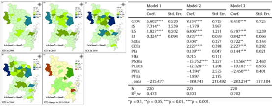
The Yangtze River Delta is one of the most industrialized regions in China. This study characterizes the spatial and temporal patterns of industrial carbon emissions (ICE) produced by secondary industry sectors in the region from 2000 to 2014. The scale and nature of ICE is measured from five aspects (involving 12 factors): gross industrial output value (GIOV), energy intensity (EI), energy structure (ES), industrial structure (IS) and the structure of industrial enterprises (the number and scale). The study establishes three panel models to analyze the effects of 12 factors on ICE at the county level. The results show that ICE increased dramatically, being 2.1 times the 2000 level (135.94 Mt CO2) in this region by 2014. The major carbon sources are the consumptions of raw coal and electricity, accounting for more than three quarters of the total ICE during the 2000e2014 period. ICE presents great spatial disparities across 66 counties in the region, being highly coincident with the Z-shaped distribution of the urban clusters in the delta. The GIOV is a major contributor to ICE growth in this region, increasing by 84.1 tC for an increase of one million yuan of GIOV. The adjustment of ES, EI and the structure of industrial enterprises can largely abate ICE. Regulating industrial structure and energy structure, reducing energy intensity and optimizing the structure of industrial enterprises are suggested as imperative measures for carbon mitigation in the region.

Spatial and temporal pattern of the total ICE in the YRD and coefficients of the panel models
Xibao Xu, Guishan Yang, Yan Tan, et al., 2017. Factors influencing industrial carbon emissions and strategies for carbon mitigation in the Yangtze River Delta of China. Journal of Cleaner Production, 142: 3607-3616.
(Information source: Nanjing Branch of CAS)

